Sugar Cane and Palaces

Arrived in Phnom Penh today, a month's worth of pictures from the Philippines waiting on my flash drive just for you!  The internet connection that I was occasionally able to use there was way too slow to have a chance of uploading pictures, so I've got a lot of catching up to do on this blog.  But let's not dwell on dreams and forget to live, Harry--today I present you with what I've done...today.
I was greeted at the airport in the morning by a Bunong student who is from Sen Monorom and has worked for the past few years with the project coordinator there, but is now attending university here in Phnom Penh.  (This is what I'll be doing for the next month, by the way!  http://www.globalteer.org/volunteer-projects.aspx?project=cambodia-bunong-hill-tribe)  He was kind enough to take me around to the touristy sites in the city all afternoon.
We began at the beautiful Buddhist temple of Wat Phnom...


"Phnom" translates to "hill" in Khmer.  Legend has it that long ago Lady Penh, a wealthy widow, discovered a hollow tree in the Mekong River.  Inside, she found four bronze statues of the Buddha.  Interpreting this as a sign that the Buddha was searching for a new home, she created a small hill and on top of it a temple in which she housed the statues.  Pilgrims came to see the temple, and ultimately the city of Phnom Penh, "the hill of the Lady Penh," sprang up around it.  Wat Phnom, or "hill temple," is now over six centuries old.

Adjoining the temple is a small museum, the most interesting features of which were dioramas depicting Cambodia's history from the building of the Angkor temples up through the Khmer Rouge era.


If you don't know much about the genocide under the Khmer Rouge (this directed most at readers around my age), you should probably go read about it on Wikipedia at the least.  I certainly didn't hear much about it in any of my history classes...

And it, like so many other pieces of history we prefer to forget, is worth making an effort to remember.  Tomorrow I will visit the "Killing Fields"at Choeung Ek and also the S21 prison, now a museum.  Preparing to be rather overwhelmed.

Photos I took the next day (we have no respect for chronology here).


On a lighter note, I visited some fancy palaces!

That's a complete model of Angkor Wat, to the right of the monk.

The Royal Palace, a complex of buildings, was the abode of King Ponhea Yat, who ruled from 1396-1463.  It was rebuilt to its present state by King Nerodom in 1886 when he moved the capital back to Phnom Penh from Oudong.

Outside the palace, I got my first taste of Cambodian street food: juice squeezed directly from sugar cane, served on ice.  Delicious, and see how all-natural it is?
It must thus be healthy, right?
That's all for now, with backtracking posts as well as further adventures to come!

Not much time!

I'm LEAVING tonight for three months in Southeast Asia.  (Meanwhile, I still have photos to post from my time at Hovenweep, but I fear it will be a while before I'm able to go back and organize them.)
First stop: the Philippines.  I'll be scuba diving almost every day for four weeks, helping with the marine conservation work of Coral Cay Conservation: http://www.coralcay.org/projects/philippines/
I may not have any internet access until April, so I wouldn't expect many updates soon, but hopefully by the next time I get to a computer I will have lots of photos and stories to share!

Another beautiful place...

I did a lot of picture-taking when I was out at Hovenweep and got to spend a lot of time appreciating that area's incredible natural beauty.  So when I was finally pulled out my camera for the first time since returning to Seattle, I was happy to see just how amazing a place I'm living in now, too.

This is what I want to do when I get old:
Sit with my friends by the lake.
What could make anyone happier?


Autumn seemed to stay late in Seattle this year.  I was shocked when I returned from Hovenweep in the beginning of December to see how many trees still had green leaves on them.  In Colorado and Utah, it had already begun snowing, and the plants definitely knew it was winter...not that many of them had green leaves in the first place.  But here, it looked thoroughly fall-ish for a rather long time.  The day I took these pictures, however, must have been the last day of residual autumn, given the weather that followed... read on if you weren't here to experience it!


Many an interesting waterfowl specimen can be found at Green Lake.
The "mohawk birds" (left) are among my favorites.

The last of the daylight shines across the lake from the cattails.


Coots gather together as darkness falls.


As a bonus from the nature gods, mere hours after I took these photos it began SNOWING in our never-quite-cold-enough-to-freeze-that-rain city.  And after about five days of that, it took perhaps one to warm up fifteen degrees and melt almost everything.  Presently, we are enjoying another rain shower.  There's an incredible planet for you.

Where's Waldo?


"Well, where DID she go?" you must be wondering.  She hasn't posted anything for... a month and a half!
Well, I am back in Seattle now, and still have many more things I want to share about my recent adventures in Utah and Colorado.  I hope to come out with these belated posts every once in a while, as I likely won't have anything quite as exciting to share about my life back home.  I've been working here and will continue to do so for the next two or three months, after which my plan is to travel to Southeast Asia...  This plan is still a work in progress, but with any luck I will have many more "fantastic journeys" to tell you about soon.

One Bridge, Two Bridge, Red Bridge, Blue Bridge!

Actually, there are three, and all red.  (Sorry to disappoint.)

Sipapu

Kachina
Owachomo


I spent part of my last weekend at Natural Bridges National Monument, which is in Utah about two hours northeast of Hovenweep.


The main attraction at Natural Bridges is...natural bridges!  Similar to arches, but must have been formed by water flowing under them.  All bridges are arches, but not all arches are bridges.  (A brief refresher course: arches are defined essentially as holes in rocks, three feet or more in diameter, but can be formed by wind erosion rather than water.)

The bridges I saw were formed in Cedar Mesa Sandstone, which was deposited about 250 million years ago (MYA) during the Permian period.  This was also when the first "mammal-like reptiles" appeared on our planet, but just before the first dinosaurs.

This stuff gets complicated, so I find pictures useful.
The Cedar Mesa sandstone is part of the Cutler Formation.  Therefore, very old stuff.  The arches at Arches NP, you may remember, are formed in Entrada Sandstone, which was deposited about 150 MYA during the Jurassic period, when the first birds appeared.  At Hovenweep, I am surrounded mostly by Dakota sandstone, which was deposited at the start of the Cretaceous period about 130 MYA, when the first flowering plants appeared and shortly before the extinction of the dinosaurs.  ("Shortly" in geologic terms=several million years.)
I drove through over 100 million years of geology in two hours!

Notice awesome zebra-stripe streaks of desert varnish!  (Sipapu Bridge)
I hiked down to Sipapu Bridge, through the bottom of the canyon (which was beautiful in the afternoon light!) to Kachina Bridge, and back up again.  I passed by a ruin site called Horsecollar along the way.  There were supposed to be some ruins just past Kachina, too, but I managed to go in the wrong direction, get kind of lost, and never find them...

The Horsecollar site from down in the canyon.
Up close.

Sipapu, Kachina, and Owachomo are all words that come from the Hopi language.  The Hopi, who today live in northern Arizona, are among the largest of the tribes which claim descent from the Ancestral Puebloans.
Sipapu refers to the hole in the earth through which the Hopi emerged into the present world, the fourth world, from the third world, where (as in the two previous worlds) things had started to go badly.  Sipapus are represented in the floors of kivas today and were eight hundred years ago as well (see my entry on Mesa Verde for more about kivas).
A kachina is a spirit being which is central to the religious life of many contemporary Pueblo cultures.  "Kachina dancers," who wear elaborate masks representing the different spirits, play an important role in some ceremonies.  Hopi artisans also carve doll versions of kachinas which are used to teach children about traditions...and sold to tourists.

Kachina Bridge from above.
Picture of kachina dolls that I stole from Wikipedia.
Owachomo means "rock mound" in Hopi, referring to the rock formation on the top of the eastern end of the bridge (right side in the picture below).  I saved hiking to Owachomo Bridge for the next morning, and got up early enough to enjoy having it all to myself:

Owachomo is the thinnest of the bridges, likely because it is the oldest.
(Kachina is much wider as it is younger; less has been eroded away since its formation.)
After spending a lovely morning beneath Owachomo, I headed from Bridges toward the town of Bluff, UT...  But that, my friends, is another story.

Green Tables?

You may not have heard of Hovenweep, but you probably have heard of Mesa Verde.  Just a couple hours to the east, in Colorado, lies the famous National Park, home to incredible cliff dwellings that have survived more than seven centuries since being built.  These structures were built at the same time and in a similar manner to those at Hovenweep, they're just much bigger:

The famous "Cliff Palace"
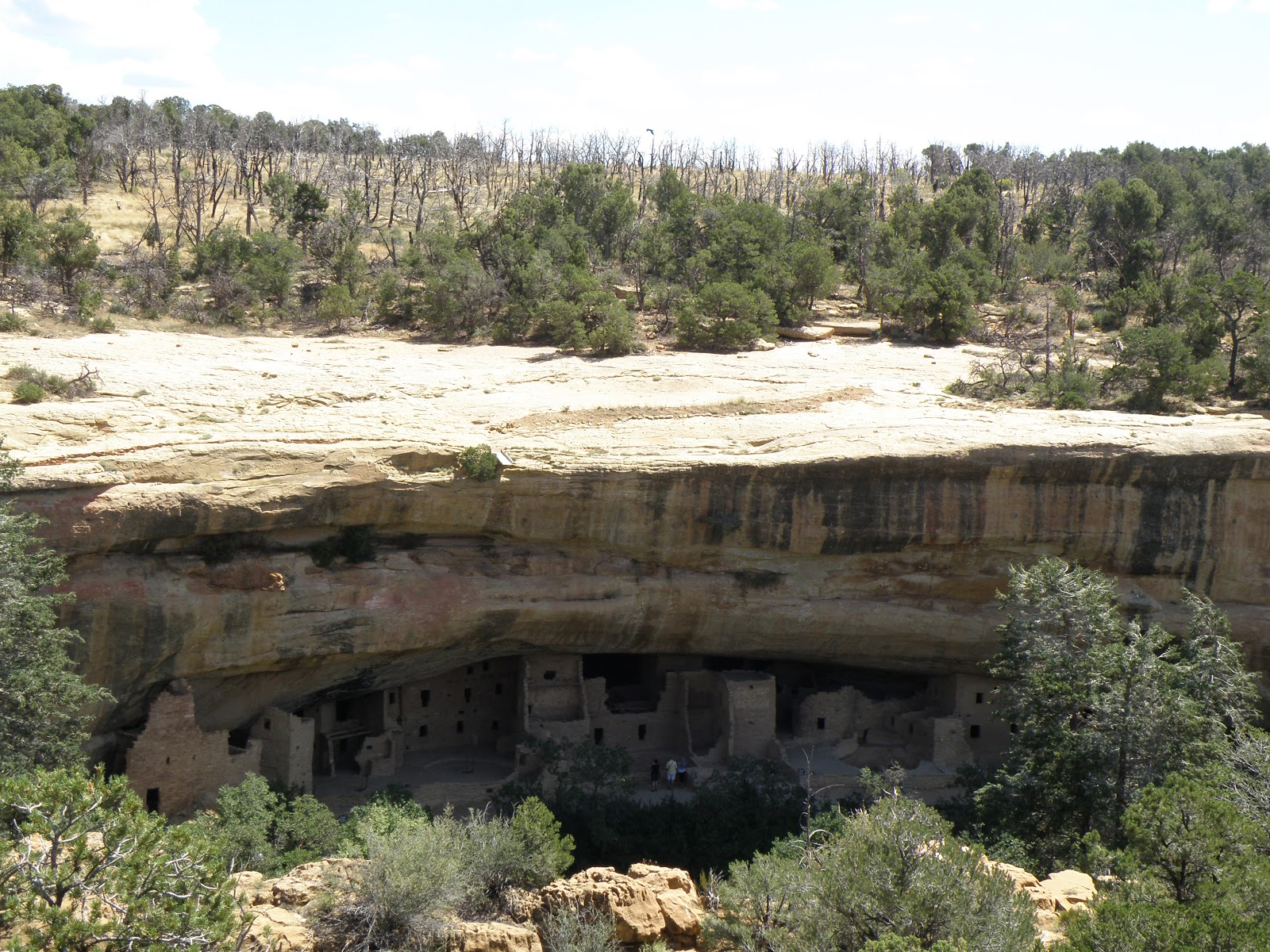
A look at Spruce Tree House tucked into a natural sandstone alcove.
Soon after arriving at Hovenweep, I decided I'd better head to Mesa Verde so I could see for myself how it compared to the Hovenweep villages.  The main difference is that while each of the groups of ruins at Hovenweep was once simply a village, the enormous cliff dwellings of Mesa Verde probably served as some sort of gathering place for those living on the mesas all around, as well as housing some people permanently.

"Mesa Verde" means "Green Table" in Spanish.  See?

The Southwest is a land of mesas: flat lands often cut through
by rivers which create deep canyons.  This one is green.
Over two days, I was able to go on tours of three of the cliff dwellings--Cliff Palace, Balcony House, and Long House--and explore Spruce Tree House and Step House on my own.  I also got to see the Far View Sites, mesa-top dwellings more like those at Hovenweep, and the Badger House Community, where you'll find "pithouse" structures built around 650 AD, a few hundred years before the development of mesa-top architecture (which was soon followed by the building in alcoves, shortly before the Ancestral Pueblo People left the area for good).

The ladder I climbed up to enter Balcony House.
The original residents did make use of ladders, but would
have gotten down from the mesa tops by climbing, via
hand- and toe-holds carved into the rock.

Ranger Shannon standing in front of the seep spring at Long House.
Life at Hovenweep villages, also, was supported by seep springs at canyon heads.


See the little person?  Imagine how much time it took for people just
like him to build this entire village into the cliff!

Something I saw a lot of at Mesa Verde were kivas.  They were built all over this region, but none of those at Hovenweep are excavated for visitors to see, so this was the first time I got to look into them.  So what is a kiva?

Two kivas--the round rooms--at Long House.
Kiva is a Hopi word for very similar subterranean rooms that are built into the ground in their villages today, though theirs are usually flat-walled.  The Hopi are one of many American Indian tribes descended from the Ancestral Pueblo People, and so while no one can know what exactly these ancient round structures were used for, archaeologists extrapolate their purpose from the use of kivas in the Hopi culture and other contemporary Pueblo cultures (where they have different names in each different language).
Kivas today are used primarily for ceremonial purposes, and serve a central function in Hopi religious life.  These ancient kivas were at one time, and still sometimes are, assumed to have been used only for ceremonies as well, but artifacts and other evidence found within them has more recently indicated that they likely served more everyday needs as well.  Especially in the winter, they would have been a warm place to retreat to when the temperatures in the open desert dropped low.  Families may have done their cooking down in kivas and spent time on crafts such as weaving there.  The kivas seen above and below are of the most standard size, big enough to fit up to ten or fifteen people comfortably.  Elsewhere in the southwest, you can see "great kivas" able to accommodate four hundred!

Occassionally, kivas are keyhole-shaped!  We don't know why
they aren't all just round.
Kivas may have evolved from pithouses, and the two types of structures do have the obvious similarity of both being built into the ground.  However, there are places where both are found having been built around the same time in the same area, signifying some difference in purpose.

The remains of a pithouse built around 650 AD.
Though original roofs do not often remain on kivas "discovered" and excavated today, kivas were covered by flat roofs, with a single opening in the top for smoke to escape and people to climb in and out on a ladder.  Mesa Verde, as some other parks, has reconstructed one kiva so that visitors can go inside and see what it feels like.  I was surprised by how spacious it seemed, though it was small enough that I wouldn't have wanted to spend too long.  Part of the claustrophobic feeling may have been because the average Ancestral Puebloan was several inches shorter than me at 5'-5'3".  I could imagine these rooms being very comfortable spaces for them.

A boy climbs out of a reconstructed kiva into the sunlight.

Autumn leaves

Just because I'm in the desert doesn't mean I'm going to let myself miss a beautiful fall color show.  Unfortunately, plants out here don't really have leaves.
 
No self-respecting Seattleite could call these leaves.
Fortunately, I have found a solution: the mountains of Colorado, just a couple hours away!


Two weekends in a row, at the end of September and start of October, I escaped out to Colorado--first to an area in the San Juan National Forest just north of Mancos and next to the town of Telluride.  After that first weekend spent hiking around in the forest surrounded by beautiful yellow aspens, I knew I couldn't miss the rest of that short window when the trees light up before the coming of winter.

A walking trail in the Transfer recreation area, north of Mancos

I slept in campsites among aspens and among willows...

Transfer
Telluride
 Wandered past waterfalls and lakes (all that water that allows these trees to grow!)...

A little fall along a hike outside of Telluride
Reflections in Alta Lakes, just south of Telluride, where I camped for a night
Lovely pond at Town Park in Telluride
I saw some red and orange trees, too...
Red aspen, Telluride
Red oaks, Transfer
Colors mixing on the same branch!
I even saw some wild photographers!

Also taking advantage of the fall colors

I hope, dear reader, that you are enjoying the autumn wherever you are.

Aspens, Telluride