Conservation in the Community

(note: I finally had the time to finish two posts in the same day, so please take a look at "Back to School" first)

All the work Coral Cay does to protect Southern Leyte's reefs would be useless if the island's communities weren't also on board with the idea of conserving these incredible places.  That's why the work of the Education Officer, who goes out to communities (especially schools) around Sogod Bay to teach about how special reefs are and why we need to protect them, is so important.  I was fortunate to have the opportunity to get involved in this education work when one school came to our base for a day of learning through fun activities!
Our awesome education officer, far right, greeting a group of students,
parents, and teachers upon their arrival at base.
The students were divided into groups which moved around to a handful of different stations: puzzles, scuba dunk tank, snorkeling, fish identification, and--the most delicious--edible coral polyp construction!

I began the morning supervising and teaching at the puzzle table with another volunteer.  Students unscrambled a couple sentences about the importance of reefs as animals' habitats and to humans, and also deciphered a coded message about the dangers of dynamite fishing and anchors to reefs.

They also tried to piece together a very difficult puzzle into the shape of a turtle:

I had a little time after this to investigate the stations other volunteers were working at.  At the "scuba dunk tank," kids got to put a mask on and a regulator in their mouths, then stick their faces in a container full of sea creatures while breathing underwater.


All the kids got to go on a snorkel led by a volunteer to see how what they were learning about played out on the real reef:

Now to the best station ever...  I got to explain to the students the anatomy of a coral polyp and what happens when a coral is bleached, and then let them go wild constructing their own coral polyps out of marshmallows, icing, and sprinkles!

A cookie serves as the calcium carbonate skeleton of the coral, a marshmallow as the polyp's "body,"
sprinkles are zoozanthelae (algae) in the icing "skin," and long marshmallows are the tentacles on top.


At the end of the day, a volunteer dressed up as an anemone damselfish to the absolute delight of the children:
Quite an adventure for us volunteers as well!

Unfortunately very hot for the guy inside the suit, but the kids loved it.

Thanks to the organizational skills of our Education Officer and the hard work of all the staff and volunteers, the day was a great success!


Back to School

(Follow along as we take a journey back in time, to seven weeks ago when I arrived in Napantao, Coral Cay's base in the Philippines!)

I've been learning a lot this year, but it's been a long time since I've been in a formal class or taken an exam...or had been, until I started SDP!  SDP=Science Development Program, the core of my Coral Cay Conservation experience in the Philippines.  Before participating as a member of a survey team, all the new volunteers have to learn how to identify just about everything they see underwater.

(All underwater photos courtesy of my fellow volunteers)


We spent two weeks studying and being tested on our knowledge of corals, fish, invertebrates, algae, and assorted other things, and practicing identifying underwater our "target species" for surveys.

Coral Cay uses volunteers to conduct a couple different types of surveys: "baseline" surveys to do basic mapping of the underwater environments off the coast of Southern Leyte, and "MPA surveys" in particularly diverse or at-risk areas where communities are interested in setting up a Marine Protected Area on their reef.  The same type of survey is used to monitor the MPAs regularly to see how they are faring under their new protection.
A map of Southern Leyte, painted on one of our walls, showing Sogod Bay in the center.
A close-up of San Fran and CCC's base.  White dots represent  MPAs.
Locals serve as the "Bantai Dagat," or "Protectors of the Reef" for each MPA, and some are protected better than others from fishing and other harmful acts.
We had a "protector," too, at base: our puppy, Bantai!
We also learned how to do Reef Check surveys, which are similar to MPA surveys but less specific to CCC's conservation work.  (Reef Check surveys are conducted all around the world by groups of volunteers to monitor reefs, often in one-day events or on longer expeditions.)


Because Coral Cay has been at this same base for a few years, and was on the other side of Sogod Bay previously, much of the area nearby has already been surveyed, and so we would ride the boat for an hour or more to sites we are now working on.  (We survey only 10 to 50 meters by 5 meters on each dive, so at least a couple of days are necessary at any one site.)  Our boat was out of commission for a couple weeks but fortunately ready to go again shortly after I finished SDP, so I got to spend a few days out on it doing real conservation work!  I also helped to paint the name and Coral Cay logo on before we put the refurbished boat back in the water.
I was covered in blue paint for days.
The boat in action.
Volunteering with CCC was the most incredible experience, and I already miss everything about being there.  The sunsets, for one, were amazing:


Sugar Cane and Palaces

Arrived in Phnom Penh today, a month's worth of pictures from the Philippines waiting on my flash drive just for you!  The internet connection that I was occasionally able to use there was way too slow to have a chance of uploading pictures, so I've got a lot of catching up to do on this blog.  But let's not dwell on dreams and forget to live, Harry--today I present you with what I've done...today.
I was greeted at the airport in the morning by a Bunong student who is from Sen Monorom and has worked for the past few years with the project coordinator there, but is now attending university here in Phnom Penh.  (This is what I'll be doing for the next month, by the way!  http://www.globalteer.org/volunteer-projects.aspx?project=cambodia-bunong-hill-tribe)  He was kind enough to take me around to the touristy sites in the city all afternoon.
We began at the beautiful Buddhist temple of Wat Phnom...


"Phnom" translates to "hill" in Khmer.  Legend has it that long ago Lady Penh, a wealthy widow, discovered a hollow tree in the Mekong River.  Inside, she found four bronze statues of the Buddha.  Interpreting this as a sign that the Buddha was searching for a new home, she created a small hill and on top of it a temple in which she housed the statues.  Pilgrims came to see the temple, and ultimately the city of Phnom Penh, "the hill of the Lady Penh," sprang up around it.  Wat Phnom, or "hill temple," is now over six centuries old.

Adjoining the temple is a small museum, the most interesting features of which were dioramas depicting Cambodia's history from the building of the Angkor temples up through the Khmer Rouge era.


If you don't know much about the genocide under the Khmer Rouge (this directed most at readers around my age), you should probably go read about it on Wikipedia at the least.  I certainly didn't hear much about it in any of my history classes...

And it, like so many other pieces of history we prefer to forget, is worth making an effort to remember.  Tomorrow I will visit the "Killing Fields"at Choeung Ek and also the S21 prison, now a museum.  Preparing to be rather overwhelmed.

Photos I took the next day (we have no respect for chronology here).


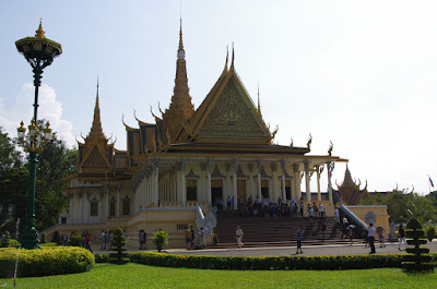
On a lighter note, I visited some fancy palaces!

That's a complete model of Angkor Wat, to the right of the monk.

The Royal Palace, a complex of buildings, was the abode of King Ponhea Yat, who ruled from 1396-1463.  It was rebuilt to its present state by King Nerodom in 1886 when he moved the capital back to Phnom Penh from Oudong.

Outside the palace, I got my first taste of Cambodian street food: juice squeezed directly from sugar cane, served on ice.  Delicious, and see how all-natural it is?
It must thus be healthy, right?
That's all for now, with backtracking posts as well as further adventures to come!

Not much time!

I'm LEAVING tonight for three months in Southeast Asia.  (Meanwhile, I still have photos to post from my time at Hovenweep, but I fear it will be a while before I'm able to go back and organize them.)
First stop: the Philippines.  I'll be scuba diving almost every day for four weeks, helping with the marine conservation work of Coral Cay Conservation: http://www.coralcay.org/projects/philippines/
I may not have any internet access until April, so I wouldn't expect many updates soon, but hopefully by the next time I get to a computer I will have lots of photos and stories to share!

Another beautiful place...

I did a lot of picture-taking when I was out at Hovenweep and got to spend a lot of time appreciating that area's incredible natural beauty.  So when I was finally pulled out my camera for the first time since returning to Seattle, I was happy to see just how amazing a place I'm living in now, too.

This is what I want to do when I get old:
Sit with my friends by the lake.
What could make anyone happier?


Autumn seemed to stay late in Seattle this year.  I was shocked when I returned from Hovenweep in the beginning of December to see how many trees still had green leaves on them.  In Colorado and Utah, it had already begun snowing, and the plants definitely knew it was winter...not that many of them had green leaves in the first place.  But here, it looked thoroughly fall-ish for a rather long time.  The day I took these pictures, however, must have been the last day of residual autumn, given the weather that followed... read on if you weren't here to experience it!


Many an interesting waterfowl specimen can be found at Green Lake.
The "mohawk birds" (left) are among my favorites.

The last of the daylight shines across the lake from the cattails.


Coots gather together as darkness falls.


As a bonus from the nature gods, mere hours after I took these photos it began SNOWING in our never-quite-cold-enough-to-freeze-that-rain city.  And after about five days of that, it took perhaps one to warm up fifteen degrees and melt almost everything.  Presently, we are enjoying another rain shower.  There's an incredible planet for you.

Where's Waldo?


"Well, where DID she go?" you must be wondering.  She hasn't posted anything for... a month and a half!
Well, I am back in Seattle now, and still have many more things I want to share about my recent adventures in Utah and Colorado.  I hope to come out with these belated posts every once in a while, as I likely won't have anything quite as exciting to share about my life back home.  I've been working here and will continue to do so for the next two or three months, after which my plan is to travel to Southeast Asia...  This plan is still a work in progress, but with any luck I will have many more "fantastic journeys" to tell you about soon.

One Bridge, Two Bridge, Red Bridge, Blue Bridge!

Actually, there are three, and all red.  (Sorry to disappoint.)

Sipapu

Kachina
Owachomo


I spent part of my last weekend at Natural Bridges National Monument, which is in Utah about two hours northeast of Hovenweep.


The main attraction at Natural Bridges is...natural bridges!  Similar to arches, but must have been formed by water flowing under them.  All bridges are arches, but not all arches are bridges.  (A brief refresher course: arches are defined essentially as holes in rocks, three feet or more in diameter, but can be formed by wind erosion rather than water.)

The bridges I saw were formed in Cedar Mesa Sandstone, which was deposited about 250 million years ago (MYA) during the Permian period.  This was also when the first "mammal-like reptiles" appeared on our planet, but just before the first dinosaurs.

This stuff gets complicated, so I find pictures useful.
The Cedar Mesa sandstone is part of the Cutler Formation.  Therefore, very old stuff.  The arches at Arches NP, you may remember, are formed in Entrada Sandstone, which was deposited about 150 MYA during the Jurassic period, when the first birds appeared.  At Hovenweep, I am surrounded mostly by Dakota sandstone, which was deposited at the start of the Cretaceous period about 130 MYA, when the first flowering plants appeared and shortly before the extinction of the dinosaurs.  ("Shortly" in geologic terms=several million years.)
I drove through over 100 million years of geology in two hours!

Notice awesome zebra-stripe streaks of desert varnish!  (Sipapu Bridge)
I hiked down to Sipapu Bridge, through the bottom of the canyon (which was beautiful in the afternoon light!) to Kachina Bridge, and back up again.  I passed by a ruin site called Horsecollar along the way.  There were supposed to be some ruins just past Kachina, too, but I managed to go in the wrong direction, get kind of lost, and never find them...

The Horsecollar site from down in the canyon.
Up close.

Sipapu, Kachina, and Owachomo are all words that come from the Hopi language.  The Hopi, who today live in northern Arizona, are among the largest of the tribes which claim descent from the Ancestral Puebloans.
Sipapu refers to the hole in the earth through which the Hopi emerged into the present world, the fourth world, from the third world, where (as in the two previous worlds) things had started to go badly.  Sipapus are represented in the floors of kivas today and were eight hundred years ago as well (see my entry on Mesa Verde for more about kivas).
A kachina is a spirit being which is central to the religious life of many contemporary Pueblo cultures.  "Kachina dancers," who wear elaborate masks representing the different spirits, play an important role in some ceremonies.  Hopi artisans also carve doll versions of kachinas which are used to teach children about traditions...and sold to tourists.

Kachina Bridge from above.
Picture of kachina dolls that I stole from Wikipedia.
Owachomo means "rock mound" in Hopi, referring to the rock formation on the top of the eastern end of the bridge (right side in the picture below).  I saved hiking to Owachomo Bridge for the next morning, and got up early enough to enjoy having it all to myself:

Owachomo is the thinnest of the bridges, likely because it is the oldest.
(Kachina is much wider as it is younger; less has been eroded away since its formation.)
After spending a lovely morning beneath Owachomo, I headed from Bridges toward the town of Bluff, UT...  But that, my friends, is another story.